
Field Notes - Tasmania Road Trip
Tasmania is a place I've wanted to visit for while, the imagery I've seen appeals to me. Forests, waterfalls, mountains and an achingly pretty coastline. I had a week to see something 'local' as I'm relocating back to UK after 20 months working in Adelaide, South Australia. Well I'd scratched my NZ itch recently so this was next on my list. Btw Western Australia would be next on my list ... but then it's a long list. Patagonia anyone?
If you visit or live in NZ (as I have) the name 'Tasman' is one that crops up quite frequently. Tasman Sea, Tasman Bridge, Tasman Highway, Tasman Glacier, Tasman River, Tasman National Park. Simply the name is enshrined in naming the very fabric of the land. Now I was visiting an entire State of Australia with a variation of the same name. Okay so my curiosity is easily satisfied on the internet and these auspicious places are all named for Abel Tasman. Who was a Dutch seaman/ explorer in the employ of the Dutch East India Company. And for being the first European to reach the large Island off the south coast of Australia (in Nov 1642) they named it after him. 'Tasmania'. Apparently there were about 7000 'first nations' people already there. But obviously they don't count if you're naming a place. Besides all the locals completely failed to sail to Europe and stake a claim to their home. Still in the casual alliteration in which Australians excel Tas, Tassie does roll off the tongue very nicely. I may have mentioned just how much I like their pithy roadside signs. 'Survive the Drive' ... 'Arrive alive'. They are a simple joy of the endlessly similar SA roads.
My plan was to do a one week road trip in a camper van. The dates were the last week the camper rental people were operating before closing for the season. I had one other confirmed date for a Wilderness cruise along the coastline between Port Arthur and Eaglehawk Neck. The date for the cruise was for the day after I arrived, so it dictated which direction I travelled from Hobart. Anti Clockwise.
To a degree this entire trip felt like quite a gamble, it was short and in the weeks preceding the trip I watched the Tassie weather with considerable interest. The cloud and rain symbols on metservice and accuweather spoke volumes . Still I thought, at least the waterfalls would be flush with rainwater. So I researched waterfalls quite extensively. And plotted a route accordingly.
The flight into Hobart happened to be an unexpected highlight. The aircraft approached the airport from the East. Which meant the pilot flew us over the coast that I was planning to explore. It looked wonderful. By the time I had my luggage i was eager to get going. Ignore that pervasive drizzle there was rugged coastline to explore. However there were a few practicalities to attend to.I collected the camper, got my 'basic training' and signed on the dotted line. This included paying an eye watering sum on my credit card as a bond. After this I needed to stock up the camper and given it was late on Sat afternoon. I'd best get cracking. In the event this proved simpler than if I were in Adelaide, which uniformly closes at 5pm on Sat. The first supermarket I came to proclaimed. Open 7 - Midnight 7 days. There had been no urgency. It was all in my mind. It looked like this might go more smoothly than I feared.
Day 1

I declined the joy of staying in the camper on the first night for the simple reason that it was all unfamiliar and I was determined to make an early start. I needed to be 90 mins down the road by 8.45, so I was booked into a motel.
I left Hobart before dawn remembering to snag some cash from a hole in the wall machine. Cash was going to be necessary for the National Parks who outside hours operate an 'honour' system for campers. Cash was needed for 'camping' and cash was needed for a 'Parks use' permit. It was dispensed in $50 notes. That wasn't helpful.
I headed for Port Arthur, site of an infamous Prison of the British Empire. During that journey a sustained drizzle and endless scrubby farmland seriously dampened my spirits. Where was the Tasmania I had come to see? Still I did stop once at a creek that caught my eye. I took a snap, not exactly masterwork but I had begun.
I made the cruise meeting spot in good time. Which is good, as I needed to sort out my photo kit. I had initially thought to take my rucksack, but a conversation with reception suggested that would be unwise. The advice was 4 layers of clothing under the waterproofs they were going to supply. In addition gloves hat etc. In the end the bag stayed put. I carried a dlsr (with it's widest lens ) and my film rangefinger (with a 800 iso film ..) wieghty tools that had me in a double stranglehold for some hours. Happily I was able to tuck one or both of them out of the way during the trip. So they weren't exposed to the weather.


At the outset it was apparent the best views were from the very front of the boat. Sadly I didn't secure one of those seats. I was a couple of rows back. Frustrating. But in the end the extreme motion of the boat, driving rain and poor light meant I just didn't take many photos anyway. The only snap I like was of the seascape further out to sea. I could have got that from the shore. But the trip was fun! no really I had fine time. Yes I repeatedly dropped my lens cap and despite four layer gloves hat etc I was distinctly chilled. It's very obvious with less weather problems it would be truly wonderful. I would definitely do this again. Although I wouldn't strangle myself with two cameras. Or if I felt very fancy I'd take a heli tour. The coastline certainly looked dramatic enough for this to be a worth a bash.

After the trip the drizzle truly set in, I like many others warmed up in the cafe next door. I recovered some semblance of myself with a coffee. My preferred campsite was only half an hour away. So I retraced my earlier route towards Hobart to see if I'd missed any points of interest. I didn't go very far. The weather really wasn't very pleasant. However the place I found most interesting was a beach framed by sand dunes and long grasses.

I made it to campsite before dark. Popped a $50 note into an envelope as I didn't get any change earlier. (doh!) The campground was mostly empty, one other camper, and a pair of small tents. Sadly there were no powered sites here. Oh dear. Power in a camper van is needed to run the heat pump (air conditioner) media centre, microwave etc etc. So it was going to be chilly. Still i had many home comforts and muddled my way through the first night. My saviour being a hot water bottle that had been suggested to me by Kate back in London. As I closed the curtains of the camper I spotted a Kookaburra on a fence post. All fluffed up against the cold. And it was presumably the same one that woke me before dawn the next day.


Day 2
Ha ha haaahahahahahahhahahah . .ha ..... There's nothing quite like the spine tingling call of a laughing kookaburra, outside it was dark. if this was the dawn chorus someone's watch was wrong. A glint of light on the horizon okay my mistake. I was just deep under tree canopy. A cup of tea was not far away. Dressing choices for this time of the morning were basically everything I'd brought with me. But wow it was chilly. Three pairs of socks did the trick. First order of the day a stroll along the beach to find some information about the walk i wanted to to. The Cape Hauy Hike. But wherever the signage is I couldn't find it. I went back to the camper, and watched as a walker disappeared into the trees. I wandered over and yes indeed this turned out to be the start of the Cape Hauy hike. The sign nicely obscured by a temporary fencing. The sun glinted through the trees. Was this going to be a nice day? No reception to check the weather. So I packed my usual hiking kit including waterproofs and burner (for a cuppa (tea) / soup). Fuel, matches milk teabags tick. You'd be surprised how often I've hiked miles to find one of those absent.

Sun, it was no mirage. It was quickly apparent I was overdressed at the route went uphill. I passed an art installation which included a pair if concrete Abalone shells. Odd thing, then came across a large garden bench. Perhaps this was a garden after all.


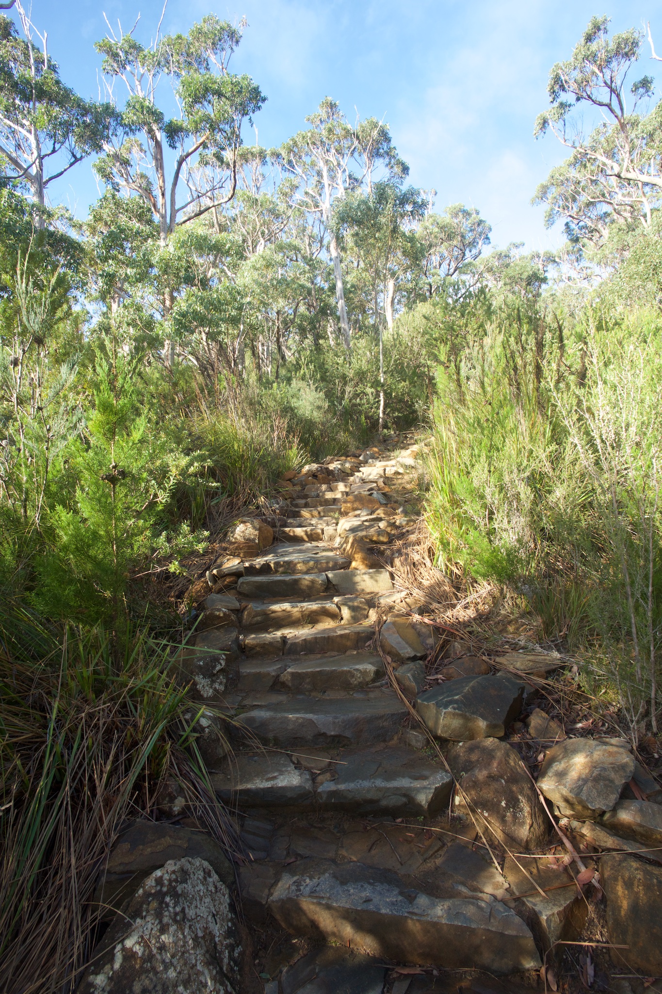
Whatever the shortcomings of their hiking signage, Aussies make a damn fine path. This one was a crazy paved stairway to the stars. Up, up, and up. Sometimes the stairs were ornate enough to be a garden feature.


The bush was a dense thicket of green, birdsong was sweet and tuneful. On the mainland the birdsong i generally hear (omitting the very tuneful Australian magpies) seems raucous and brash. This was birdSONG how wonderfully different.


The backlit clouds and unknown shores and islands in the far distance. I stayed at the summit for a good while soaking up the view.


A pair of hikers who could easily have been the ones I saw earlier marched past heading for the carpark. Impressive, for myself there was no hurry. I was just where i wanted to be. Having reached the first summit the rest of the walk was spread out before you like a map. The route a narrow thread through low scrub.As I progressed so did the view and of course the camera got a good thrashing. I found myself at the Cape all too soon. A grandstand view of the pillar. Sea boiling far below. A wonderful climax to a great hike.


The sun held good for the entire walk back to the camper. If this was were to be the only walk I did in Tassie, then it was a damn fine one. Back in the camper I brewed tea, then hit the road north. My destination Freycinet National Park. The dum dum suggested I would get there about 8.30 pm ... well no point lingering here. As i moved off drawers slid open and cabinet doors banged loudly, a solitary bottle rolled the entire length of the floor. *****! everything needed to be shipshape Bristol Fashion before setting forth.
Near the end of the ten kms of compacted gravel, (30kph only) A distinctly fat Kookaburra glided across my view to perch roadside. Back on the sealed road the camper drove well. I did a steady 80kph. Sitting high I got a wonderful view until the sun went down at 5.45pm. late June the shortest days of the year in the southern hemisphere. To a degree it felt wrong to be driving at night. I'd miss so much. But if I were to get to the known good stuff such as waterfalls, national parks I needed to get going. A full moon gave me glimpses of interesting coastline to my right. I didn't stop. I'd been going since dawn. Push on to find coffee that never came. The road into Freycinet was a variable speed limit. 80 kph mostly but dawn to dusk 55 max for the wildlife. The dum dums beeps kept me honest. Despite my hurry to park up.
At the out of hours check in I realised I still hadn't got the right change ... the post box swallowed another $50 note. But this campsite had POWERED sites. I stopped at number 3. And tried to hook up to the power point on the passenger side. Hell the socket was the wrong gender. I had the wrong cable how did that happen? Damn. Well I hadn't the will to do anything except heat up some food and some water for a hotwater bottle.
Day 3
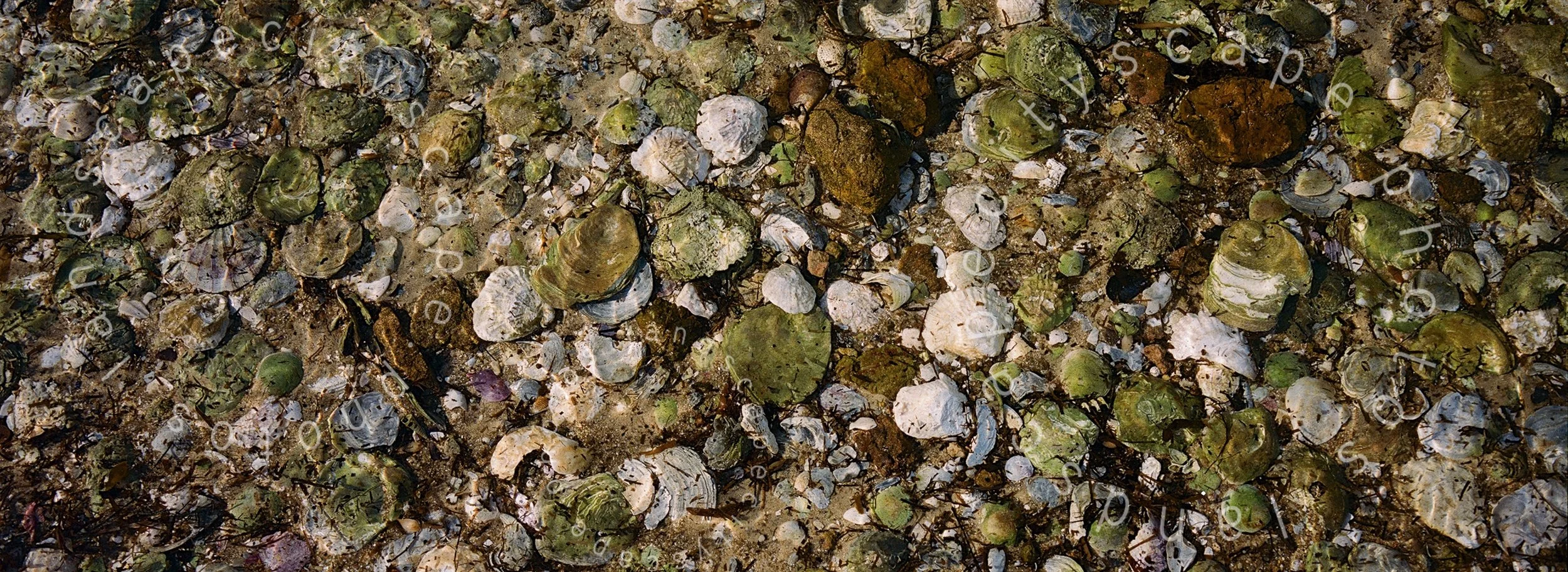
I shuffled around the small space in my outfit of many layers and pulled back the edge of a curtain to a cloudless cobalt sky. Ten minutes later I was enjoying early morning sun on Coles Beach. Bright light and the gentle wash of the sea created wonderfully complex and changing 'caustic' patterns on the sand. The beach was littered with shells. Nothing grandiose but an abundance of shell types I'd seen in both NZ and Aus. bleached white Oyster shells were everywhere I walked.


I checked into the visitor centre to enquire about a hike I wanted to do. A few small details such as where was the start? A further 4 kms into the park along the main road was the answer. A carpark meant I could just drive there. I did happen to phone the camper company about the power cable. Apparently the INPUT socket was unmarked under waterproof cap on the opposite side of the van .. doh! The walk I did is called The Mt Amos Summit Hike, it was the best weather and the best day of my week in Tassie. If I thought my day at Cape Hauy was lucky this was a day I shall never forget. I wrote a separate account of it. (Field Notes - Mt Amos Summit Hike) But here's a couple of pix.


Day 4 East Coast
I woke still with smile on my face from the day before. I checked my photographs to make sure I hadn't imagined it. Wow what a fantastic day!
The plan today was a long driving day, my goal was to be at Cradle Lake by the end of the day I was loathe to leave Freycinet before I'd fully explored this park but I'd already had fully half my holiday on the East Coast. Time to head for the dark heart of Tasmania, forests, mountains and waterfalls Before I left Freycinet I nipped over to the Cape Tourville Lighthouse to catch the the 'nuggets' at sunrise. Not an ideal viewpoint but very few options that i could see.

I didn't escape the park quickly but by small painful increments and I stopped to take snaps. This place is wonderful I could happily take pictures around here for my full week.


From Freyincet I headed North. I had a couple of locations on my hit list, in particular my first Tassie waterfall, Liffey Falls. By the 'dumdumb' it seemed quite close to Cradle Mountain. When will I learn ?
I was enjoying a scenic drive when I caught a rocky cove out of the corner of my eye. Sun glinted on the Tasman Sea and highlighted the red lichen on the rocks. Good enough for me. Out came the xpan (my film camera) . It's batteries gave out on the first shot. Damn .no spares.. this was just the type of scene at which it excels. Still I'm happy to say the digital cam was pretty damn good too.


I stayed here for lunch then back to the road. i got to St Helens. (the largest town I'd got to on the East Coast) before I realised time was running out to get to Liffey Falls before sunset. possibly with a bit of sun. (.. if the weather held). Decision made. The dumdumb suggested a route that would get me there at 5.30 ...suspiciously Google agreed. Off I went, which coincidentally meant turning around and going the way I'd come. The A4 headed into the interior and I left the coast for the first time driving straight through the farming heartland. Featureless valleys, and field after field of grass. I wondered where the livestock were then rather swiftly tried to think of something else. btw I did learn that in atypical candour Aussies don't use the french word abattoir. Preferring 'slaughterhouse' on their signage.

The best part of 3 hours after leaving St Helens I turned into the Liffey falls reserve. Then a further half hour along gravel brought me to the near empty carpark. A photographer with a monster manfrotto tripod emerged from the woods grinning and chatting to someone lugging an equally big camera rucksack. The light was already very dim within the tree canopy. Sunset was only 10 mins away. The trail sign said Liffey Falls 20 mins away HOW FAR is that ?I half jogged down the path with all my camera kit. Passing through a tremendous glade of tree ferns and was at the falls in short order. I hopped over a barrier
Okay photographers will understand this. Most people will baulk at the idea of crossing a safety barrier. Well everyone makes a personal choice on safety. At that moment the water was low, no rocks were moving around and the biggest danger was probably slipping on a wet rock and turning my ankle. What can I say? I had boots on. Besides on this occasion I followed a well trodden path around the pebbles and rocks.
When I looked back to the falls there was a massive log wedged in the middle of the picture. Well I came to take a snap and snap away I did. Fortuitously the sliver of sky above the falls went orange and pink as I bashed out my pano. A moment later the colour had gone. And so had the light. I was very lucky to catch that moment but I'm still miffed by the log in the centre of the picture. As i walked back the tree ferns were simply looming shadows. To get that shot I should have been there earlier. I rued my sidetrip to St Helens.
The dumdumb said two and a half hours to Cradle Mountain. I just hoped there would be coffee on route. No such luck. In fact there was little of anything on the road. I turned left off a main road near Deloraine and rarely needed to dip the headline beams for traffic coming towards me. 2 hours on the road and suddenly visibility was reduced. I'd driven into a mist or cloud bank. I halved my speed, then halved it again. 20 Kph back up to 35 Kph back to 20 kph. As i took the turning for Cradle Lake 8km I was back up to 50kph. But it was gone 9,30 pm. I was tired ready to stop. But simply nowhere to park up. No open holiday park. Lots of signs saying no camping. Hmm google provided a spot. 20 Mins back the way I'd just come. Or rather 20 Mins at normal pace but in this pea soup? I eventually stopped the engine At Lake Alexandria Campsite gone 10.15 pm. I heated hot water for a hot water bottle and was asleep by 10.30. A very long day. I'd been driving since before dawn.
Day 5
Damn I still woke before dawn. I peeked out the camper window. Still in the low cloud. And I was in what appeared to a be sodden field. I wondered if the camper had settled into the turf. Apparently not, luckily I stopped whilst still on the path in which was reinforced with hardcore. Phew. Eventually i reversed out but breakfast was an urgent need, I'd missed my evening meal. I will long remember the journey I took that morning from Lake Alexandria to Cradle Mountain. The entire world was wreathed in mist. The whole world was grey and mysterious.


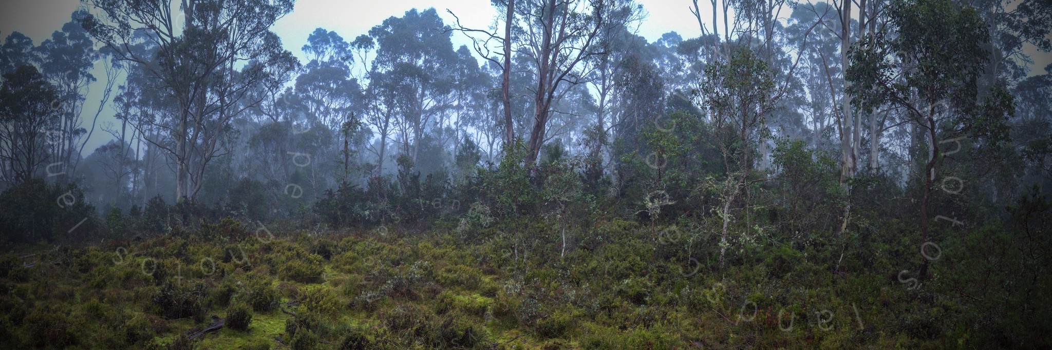


The 30 min drive took me 3 hours and yielded some of my favourite images of the trip, nuff said. I was in no hurry, if Cradle Mountain weather was anything like where i was I would never see the actual mountain. I snapped away with a happy heart, and slightly cold fingers.
To my great surprise when I parked at the visitor centre the cloud/ mist had vanished. The heavens were purest cobalt. How lucky was that ? Thank you very much. One parks use permit please and a bus ride to Dove Lake that provided a picture postcard view. Not a ripple on the lake. Or more accurately not a ripple until a pair of Asian children started throwing stones into the water. I got one try ahead of the barrage of pebbles then a slight breeze caught the water. Well sometimes one chance is all you need. Could this day get any better?

I declined the idea of doing the Dove lake circuit on the basis I'd seen two things of interest on the bus ride in. The first was the Cascade Waterfall, the other were Wombats. Okay I'm not geared for wildlife but these beasties are supposed to be nocturnal. What on earth were they doing wandering around in DAYLIGHT. So I hopped back on the bus to the Visitor Centre. On the way snagging both.


Oh and you're not allowed to stroll over the turf. Cradle mountain is a site of amazing vegetation. Not sure what this is but very spongy and everywhere ... and bipeds like me can compress the ground and damage it unthinkingly.

So okay this day just went well. I've been carrying a camera almost everyday for over a decade, and don't think I've ever had a more productive morning. The cameras went back in the bag by 1pm and I was done for the day. Feeling excited if not a little smug. The horrid drive the night before had been entirely worthwhile.
Off to Strahan (pronouced straaawn .. apparently) The drive was mercifully simple. An interesting and fast road. I passed a big sign that Proclaimed 'Gold Mine'. Predictably there were a pair of very solid looking metal gates. I also passed the sign to the Murchison Dam. Sorry not stopping now. My spirits were high and it was downhill all the way I think the camper enjoyed the trip as much as i did . I grabbed fuel at Queenstown, which (on a large information board as you enter the district) proclaims itself 'copperopolis'. It's a mining town through and through. Interesting for some no doubt, but I lingered only long enough to find a way out.
Day 6
Another dawn start, being in a camper obviously has a beneficial effect on my lifestyle. No midnight internet. Actually no internet at all. I was unplugged this holiday ...and enjoying it. Clouds had crowded out the sky. I had a tentative idea to do the Gordon River Wilderness Cruise but not on a grim day. Still Straaawn was a pleasant location with some very impressive municipal buildings. The post office and customs house both caught my eye.


But for me the police station was the highlight. It's cottage scale and design gave me the idea this was the parish of a 'local' bobby. I warmed to Straawn ... and was happy to find a good campsite with a powered site for me. So after some basic maintenance, (the less said about emptying the camper loo the better ....) anyway I hit the road back towards Queenstown and swiftly back out again on the Lyell Highway heading for Derwent Bridge.
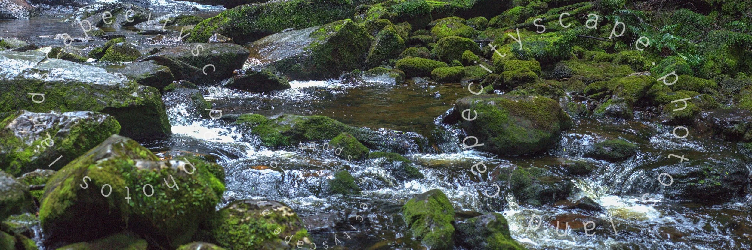
The road passed over an impressive stretch of water that I later found out was Lake Burbury. A distinctive plimsole line of earth all around it's circumference suggested it wasn't a natural lake and further researches confirm it's a manmade reservoir. However my next stop was not long coming. Nelson Falls happened along at just the time I wanted a break. So I did. It was not planned in the same way as say Liffey Falls. So I considered this a 'find'. I knew nothing about it before getting there. And what a wonderful surprise. A ten minute walk brought me to a gushing jewel in the forest. So I stayed a while and had a lot of fun.
Memorably for me a Pink Breasted Robin fluttered in front of my face for several seconds whilst I was perched on slippery rocks. It's breast was the brightest hue of anything I'd seen in Tasmania. Under the gloom of the rainforest canopy it was like someone had turned on a lamp. I was so entranced I came perilously close to slipping into the water beside me ( only a foot deep) I watched in wonderment as it fluttered around in front of me. Now that, even more than the wombats was good cause to carry a longer lens. I have no photo of the Pink Breasted Robin but the colour is etched into my retina. The snap of the waterfall came out pretty good but the bird shot is one that got away.


On towards Derwent Bridge, Derwent is just one a huge number of familiar place names to me. I associate the name most with a set of drawing pencils that I've used for years. I stopped twice before I got to the eponymous bridge. Once for a particularly fine forest of mature gumtrees.

And the other at a scene of utter desolation. Where strips either side of a river had been clear cut. The hand of man had rarely felt more clumsy than on this stretch of nature. There's a good reason for it. I've no doubt of that, but I just stopped dead when I saw this part of the Tasmanian Wilderness.


My stop at Nelson falls, and at the detour to see the clearcut had really eaten into the clock. I was still a long ways from my final destination. Mount Field National Park. I'd hoped to get there in time to photograph one of Tassies most iconic waterfalls, Russell Falls. But that wasn't happening. I would be arriving in the dark.
I sat high and watched the miles roll by in comfort. Zipped past all lagoons, and lakes in profusion. And for a while the road followed pipes that led a massive Hydro Electric scheme. I turned right from the main road near Hamilton and drove into another low cloud or possibly fogbank. I edged along the road to the consternation of locals with flatbed pickups, who saw no reason to slow down. I let them pass and rolled into the park gone 8pm. I could barely see twenty feet ahead . but this was exactly what I needed amenities, including an external camper power cable. water supply ect. And this time I even had the right cash for the envelope...$50.
Day 7
I woke sure with the knowledge this was the right place to be. It was Saturday morning i was an hour from Hobart (where I needed to return the camper later) and I had most of the day to explore the Park.

In short I was hoofing along the metalled path to the first point of interest before 8pm. Perhaps I was finally getting the hang of this camper thing. Shame this was the last day of my adventure.
The decaying body of an enormous tree suggested BIG things ahead. Plants are good indicators of the place you're in. Simply put cactus thrive in one environment , moss in another. Tree ferns seem to enjoy the same climate as moss.
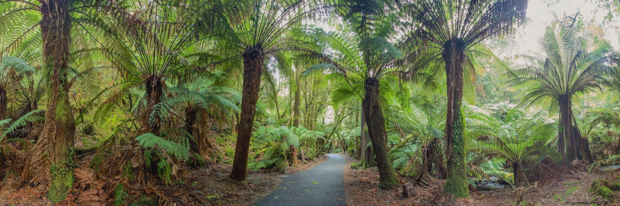
An impressive stand of tree ferns suggested there was lots of water around. There was. Lots and lots of water. Russell Falls is a tiered-cascade which drops almost 300 metres. And owing to good recent rainfall it looked wonderful. A constant flow of water in headlong freefall down. Splish splash this really was a wonderful waterfall. I bashed away with my inimitable method clickedy click. Then again. I tried a couple of compositions.


When i got home I found that the most famous image of this place was taken by someone who had scaled the cliff behind me. Hmm lesson learned, NEXT time I carry ropes with me. errrr or maybe not. Tassie is famed for some nasty beasties in the woods.
Satisfied I'd got something. I carried on for twenty mins up a boardwalk to Horseshoe falls. More contained, but equally 'wonderfall'? Yes it was. There was another waterfall. I moved on to try and get an image of the massive trees of this mature rainforest. I wondered if the blackened bark was an indication of a previous forest fire. So far the internet has not provided an answer.
This is where my picture safari ended. I was elated, tired and ready for a really good scrub in a hot shower. Camper return was simpler than pickup happily there was no question about my credit card bond and they processed the return then and there.