Six hours north of Adelaide is a world away from the lush farmland and vineyards that characterise the area I live in.
On the road to Wilpena Pound
The Flinders and Heysen mountain ranges grow up sharply from the floodplains of SA, and they have been on my photographic radar for several months. I had wanted to venture up there for a Christmas trip, but temperatures in excess of 40 C suggested it would be better to wait for the cooler months.
March has definitely been a cooler month in South Australia, and the Adelaide Cup public holiday meant a long weekend. For me this was the ideal opportunity to finally head north to Wilpena Pound.


Wilpena is a huge crater shape formed by erosion on the edge of the Heysen range of mountains. It's a national park I was particularly interested in investigating. So up I went in a campervan. It's charms were immediately apparent as I saw Eagles , Kangaroo and Emu's before I'd even arrived. And the carpark was full of wildlife too.


The Saturday was very warm and walking wouldn't have been a good choice, so I took the advice of a park ranger and did a scenic drive along the Bunnyeroo Valley. I did think to ask if it was suitable for a long wheelbase camper, the ranger thought it would be fine if I took it easy through the dry riverbeds. Which should have told me something.
The gravel road into the mountains was certainly scenic. The midday sun may not have been the ideal light for photography. Didn't matter, I edged along very slowly stopping whenever the fancy took me. Sometimes it was a photo, sometimes it was just to let someone past.
View from the scenic viewpoint - Bunnyeroo Valley
I was much taken with the view from the 'scenic viewpoint'. Early on I saw a very large eagle on the ground and very near the end a falcon. Otherwise any wildlife that might be seen from the road had made itself scarce before I could spot it. Still I'd got very lucky by seeing so much wildlife on my journey into the park. I had to be content with the views and the flora, which included lots of these fruits. (And no I didn't try one).


Brachina Gorge
The Bunnyeroo Valley road and the Brachina Gorge road are 32kms of twisty lumpy road and even though I had entirely the wrong vehicle I'm a fan. The final view of the Heysen Ranges was wonderful and well worth the effort getting there..
Heysen Ranges
If you go it's worth noting than you have a choice to go back the whole way on the same road or or take the 70km route back on metalled roads. I took the long way round, then spent a night in the Resort campground. To my immense joy there were hot showers waiting for me.
The next day was predicted to be cooler. I planned an early start to head up the St Mary's Peak trail. I didn't try for the 4am start the guide suggests. But I was on the move by 8am.. I got the weather report from the Information Officeat the head of the trail. Very warm apparently. The duty person also asked me not to climb to the summit, as it was an important native dreaming site. And a sacred spot. It wasn't a ban, it was a request. I took the opportunity for a quick cup of coffee and I was on my way.
Setting off my backpack felt decidedly heavy for how little I was carrying. I had my camera, tripod and a couple of lens, plenty of sunscreen, 2 litres of fresh water, snacks and a sandwich for lunch. I also had a fleece. (It's always breezy on the top of mountains). I had thought to bring a burner to get a cuppa at the top, but forgot a pan to heat water in. Oh well next time!
The route was well marked, blue triangles nailed to trees and boulders. Further along these switched to stakes with reflective markers.
The first few kms were literally a stroll through the woods. if you cared to look the webs of golden orb spiders were everywhere. A very worn boot elegantly hanging from a branch indicated to me a minor tragedy. I hoped they'd had a pair of thick socks with them.
Several pairs of walkers passed me. One pair who had started much earlier were walking in the opposite direction, on the last section home. Big smiles on their faces. We exchanged pleasantries whilst scrambling over some rocks.


The trail edged uphill and I got a few glimpses of the Peak. The pine forest made way for bushes and scrub. The walking was interspersed with scrambling over rocks and a bit of easy climbing. After a good bit of walk / climb /scrabbling i got to a ledge with a view and did my first pano of the day. The view was fine, but it was the same one I'd continue seeing to the top. Gaining altitude wasn't really changing my perspective a huge amount.
Having bagged a pano I followed some voices uphill and met a group of 3 girls who had lost the path. And now, so had I. In truth the path is well marked. But other people had confused the trail by going off piste then marking their false trails with cairns. There then followed an interesting 20 mins where I joined the quest to find the 'true' path. made more difficult as the cairns always seemed to indicate a likely route. We would follow a 'path' only to get to a deadend. Hugely frustrating. Happily between the 4 of us we were able to retrace our steps to an 'official marker'. Then having regained the trail we spent the best part of an hour climbing to the Tanderra Saddle. Which was where the park warden had asked me to stop. It was a fair view - we had a view of the peak and the spine of the mountain range was spread out below us.
St Mary's Peak as seen from Tanderra Saddle. With Heysen ranges in the distance
The girls had mobile reception and decided to call home. I donned my fleece and set up another panorama. When they joined me there was a discussion whether or not to continue up. Two were for it, one was against. I listened to their decision process, shared my grapes and wondered if I had enough water to share on. I'd already gone through more than half my own supply.
They chose to call it a day. The view was wonderful, and in my opinion going to the summit wasn't going to improve it significantly. Secondly they were just about out of water, and on the hot day they were at least two hours from base and they were all being chilled by the strong breeze. I decided not to set a poor example and said I'd be heading down shortly. Heading for the summit of the peak would have put them into needless peril. They live close by and could easily return another day to bag the peak. A small blemish for their first backcountry trek.
The girls headed downhill (I got an email a week later to say they made it safe). I followed them down not long after. It was hot, I'd had a fine walk, and it looked all set to cloud over. Minutes after I started home a series of paired walkers passed me intend on bagging the summit. I was interested to note how little they carried. One couple didn't even seem to have a water bottle between them.
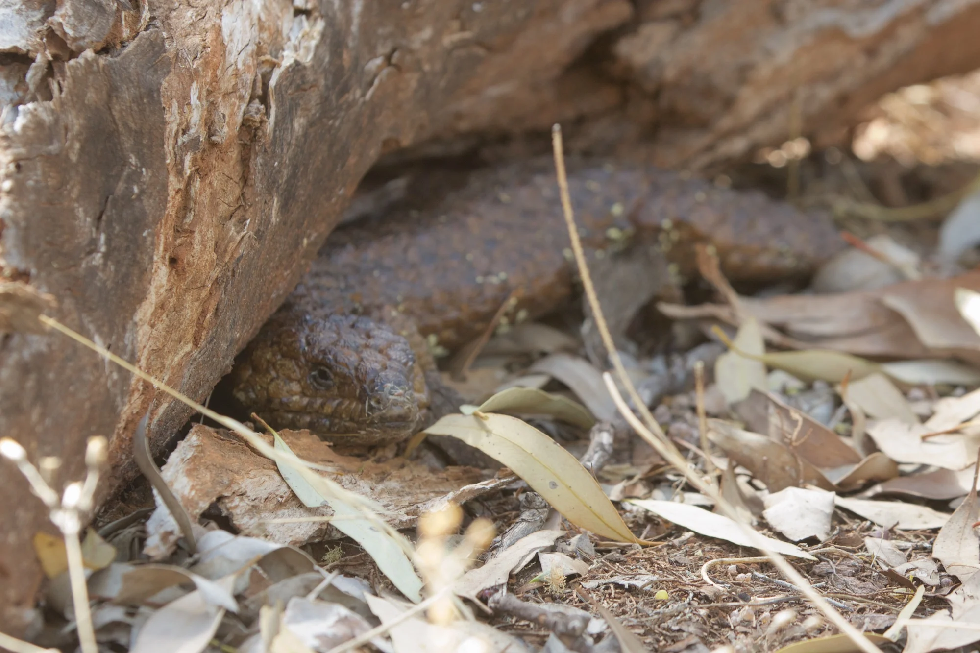
The path downhill was so well marked I was amazed I'd lost it on the way up. Everything got a lot more pleasant when I was back under the shade of the tree line. Back to walking, rather than scrambling among the rock piles. More spiders webs. Even the odd bit of birdsong. Near the head of the trail a large slow lizard heard me coming and moved out of sunny patch and under a log. A mob of fluorescent green parrots noisily attacked a crop of seed pods on a shrub nearby. I got lucky snapping a pic and headed back to base happy with the day. Which improved immeasurably with an ice cream followed by a hot shower.
Wilpena charmed me. The walk was fine, the views tremendous and some wonderful wildlife. Definitely going back if I get an opportunity. I may not have 'bagged' St Mary's peak. But then the view from the Tandarra Saddle is mighty fine too.
On the homeward trip sun broke through the low cloud cover and my final view of the area was of 'God Rays' over the sheep hills. As I stood at the edge of the road I was briefly deafened by the road noise of a pickup as it passed me at high speed needlessly sounding a flat noted horn as it went.